

Tropical Storm: Tropical Storm Nari made landfall in Hokkaido, bringing heavy rains, high winds, and dangerous sea conditions.
Tropical Storm Nari has made landfall in Japan’s Hokkaido region.
Officials warn about high winds, rough seas, and possible flooding.
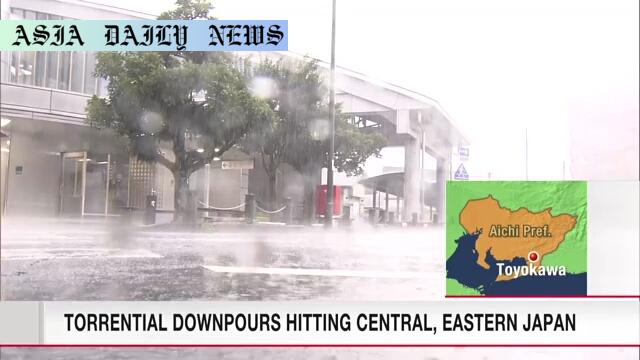
Severe rain expected in Tokai and Kanto-Koshin regions until Thursday.
Risks include landslides, swollen rivers, hail, and tornadoes.
Tropical Storm Nari Strikes Hokkaido
A powerful tropical storm, named Nari, made its landfall on the northern island of Hokkaido, Japan, early on Tuesday morning near Cape Erimo at approximately 2:00 a.m. The Japan Meteorological Agency has issued warnings about the potential for high winds, rough seas, localized flooding, and other hazardous weather conditions. Strong gusts and heavy downpours are expected to impact the region significantly throughout the day.
Residents have been cautioned against stepping outdoors unnecessarily, as wind speeds are likely to increase further, creating unsafe travel conditions. Officials are also emphasizing the potential dangers of the storm’s accompanying waves, which pose a risk to coastal areas. Furthermore, some parts of Hokkaido may receive as much as 120 millimeters of rainfall within a 24-hour period, which could result in localized flooding in low-lying areas and swelling of nearby rivers.
Severe Atmospheric Instability in Eastern Japan
While Hokkaido faces the brunt of Tropical Storm Nari, eastern Japan is simultaneously experiencing severe atmospheric instability. The resultant weather is largely caused by a low-pressure system in the Sea of Japan, which has drawn in warmth and moisture from the south. This convergence of air masses has produced large, developed rain clouds, leading to substantial rainfall in areas such as Fuji City in Shizuoka Prefecture. In just one hour on Tuesday morning, the city recorded an alarming 51 millimeters of rainfall.
Strong gusty winds resembling tornadoes also swept through parts of Shizuoka City’s Suruga Ward on Monday evening. In response, officials released tornado advisories, urging residents to remain vigilant and seek sturdy shelter. The forecast indicates that these intense weather patterns will persist in both the Tokai and Kanto-Koshin regions. Rainfall estimates predict another 150 to 200 millimeters over the span of 48 hours, placing countless areas at significant risk of further weather-related incidents such as landslides, flooding, and hailstorms.
Precautions and Broader Effects
Given the scale of the impact, authorities are urging individuals across all affected regions in Japan to take appropriate precautions. From securing loose items that could become hazardous during high winds to avoiding flood-prone zones, people are being reminded of their critical role in staying safe. Emergency alerts and evacuation orders may also be deployed as necessary, depending on how conditions evolve over the next few days. Consistent updates through official communication channels will help residents prepare and respond effectively.
Beyond imminent dangers such as landslides and flooding, officials are also warning against indirect risks. These include lightning strikes during thunderstorms and the damage caused by hail. Coastal and agricultural communities are especially vulnerable, as the adverse weather could lead to both structural damages and disrupted harvests. Yet, with adequate planning and adherence to local advisories, the loss of life and property damage could be minimized.
Commentary
The Growing Impact of Tropical Storms
The recent landfall of Tropical Storm Nari highlights the growing challenges posed by extreme weather events, particularly for countries like Japan that are frequently subjected to typhoons and tropical storms. As global climate patterns become more unpredictable, storms such as Nari are bringing increasingly severe weather phenomena, including high winds, torrential rains, and coastal erosion, leading to both immediate and long-term impacts on affected regions.
One critical aspect of this storm is its impact on infrastructure and daily life in both Hokkaido and eastern Japan. Roadways, public transport, and local businesses are often the first to feel the disruption caused by flooding and gusty winds. Additionally, residents are left dealing with power outages and property damages. These broader consequences are a reminder of the importance of community preparedness and disaster management strategies.
It’s also imperative to recognize the shared role of both local residents and governmental authorities in mitigating the effects of such severe weather. While proper city planning and meteorological warnings are a step in the right direction, individuals must also remain informed and proactive. Adapting building designs, maintaining emergency preparedness kits, and staying connected to real-time updates are small but significant steps in ensuring safety.
As we reflect on storms like Nari, there’s a pressing need to understand the linkage between human activity and climate extremities. The cumulative effect of global warming has led to more frequent unpredictable weather patterns, increasing the urgency for tighter environmental regulations and sustainable practices. Addressing these root causes may help to curb the intensity of storms in the future and protect vulnerable communities from their widespread effects.