

Thunderstorms could hit western and eastern Japan through Wednesday as a new low-pressure system develops over the Sea of Japan.
Thunderstorms will hit western and eastern Japan through Wednesday.
Rainfall could reach up to 200mm in some regions, with risks of landslides.
Storm Nari may approach and impact eastern and northern Japan.
Authorities urge residents to prepare for flooding, lightning, and strong winds.
Storm Patterns Set to Impact Japan’s Regions
Japanese weather officials have issued serious warnings regarding thunderstorms expected to affect western and eastern parts of Japan through Wednesday. The adverse weather conditions are primarily attributed to a tropical depression in the East China Sea, which is drawing warm and moist air and generating rain clouds. This weather system, initially forecasted to weaken by Monday morning, will be succeeded by a new low-pressure system forming over the western Sea of Japan. Together, these systems are poised to trigger localized downpours accompanied by lightning strikes over the next few days.
Rainfall projections highlight that up to 200 millimeters of rain will drench the Tokai and Shikoku regions in the 24 hours leading up to Tuesday morning. The Kinki region may experience up to 180 millimeters, while the southern parts of Kyushu and Chugoku are set to see around 80 millimeters. Meteorological projections further indicate an additional 150 millimeters of rain in the Tokai region in the 24 hours culminating Wednesday morning. Concerned authorities are urging heightened vigilance, particularly in areas susceptible to landslides, urban flooding, and swollen rivers.
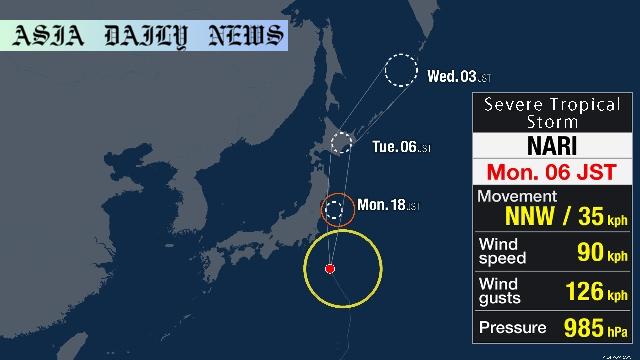
Severe Tropical Storm Nari: A Looming Threat
Adding complexity to an already turbulent weather scenario, Severe Tropical Storm Nari is tracking eastward over waters south of Hachijojima, an island strategically located south of Honshu, Japan’s main island. Forecasts predict Nari may approach eastern and northern Japan by Tuesday, with a chance of making landfall. The storm’s anticipated effects include powerful wind gusts, torrential rain, and exceptionally high sea waves. Notably, wave heights are projected to reach up to seven meters along the Tohoku coast and six meters off the Kanto coastline. Travelers and coastal communities are being advised to exercise extreme caution.
Precautionary Measures for Public Safety
Authorities have issued comprehensive guidelines to help residents navigate the coming days securely. Alongside rain-related risks such as landslides and flooding, lightning strikes and severe wind gusts—including tornadoes—pose imminent threats. The public is also reminded to remain informed about real-time weather updates while making safety their utmost priority. Preparative actions such as avoiding unnecessary travel, fortifying property, and assembling emergency kits are being strongly advised in vulnerable areas.
In summary, the coming days could prove challenging for much of Japan as it braces for both thunderstorms and the possible wrath of Tropical Storm Nari. Officials and meteorologists alike are emphasizing preparation and caution to minimize potential damages and safeguard lives.
Commentary
Unpacking the Implications of Japan’s Severe Weather Conditions
Japan’s susceptibility to severe weather underscores the pressing importance of weather monitoring and hazard preparedness. This week’s forecast is a stark reminder of how tropical depressions, even those predicted to weaken, can nonetheless catalyze conditions that pose risks to lives and infrastructure. The combination of expected thunderstorms with localized downpours, as well as the emergence of new low-pressure systems, signals a need for heightened community awareness.
What sets this weather alert apart is the intricate interplay of multiple meteorological phenomena. When coupled with Severe Tropical Storm Nari’s impending advance, the western and eastern parts of Japan find themselves bracing for compounded disruptions. The risk isn’t merely limited to rain and potential flooding but extends to violent winds, high waves, and even tornadoes, placing more lives at potential risk. For coastal and low-lying communities, the stakes are undoubtedly higher as they balance the necessity of routine operations with ensuring safety compliance.
From a broader perspective, the forecast raises concerns about climate resilience and urban planning in Japan’s densely populated regions. Amid an atmosphere of increasingly unpredictable weather patterns due to global climate shifts, the nation will need to bolster systems of disaster mitigation and emergency response. These could include bolstered infrastructure to handle heavy rains and expanded early warning systems to better prepare residents. Equally important is proactive community engagement in emergency drills and educating the public about navigating meteorological emergencies with confidence.
In conclusion, Japan’s current weather predicament serves as a crucial call for vigilance. Individual and collective preparedness can make the difference between navigating through the next few days safely or experiencing preventable harm. As the nation watches the storm systems unfold, there is an opportunity not just to respond but to reflect and improve upon disaster resilience strategies in the long term.